
EuroGA Airports
Airports was created to support general aviation activity, with a particular focus on Europe. It runs alongside EuroGA which was created in 2012 and has become a hugely popular European general aviation community.
Pilots are invited to contribute reports on airports they have visited, and interestings things in the vicinity.
The Airports database already includes basic data (ICAO code, name and city name, location) for
- worldwide 4-letter ICAO codes e.g. LKPR (Prague)
-
French numeric codes e.g. LF1454 (Rouvres)
- UK numeric codes e.g. EG29 (Plockton)
- Czech 6-letter codes e.g. LKBUDK (Budkovice)
The database contains around 15,000 airports.
Not included are
- US 3-letter names (e.g. PHX); use KPHX
- 3-letter IATA names
ZZZZ airports (user specified name and coordinates) are supported - see below under Creating a New Entry.
Search Database
If looking for a specific airport, enter its ICAO code. The ICAO code field supports the * wild card so e.g. ED* finds all airports in Germany with reports, with the most recently added at the top. Entering ZZZZ lists all user-created airports.
The Country field can be either a 3-letter code based on the list at ISO3166-1 Alpha-3, or a country name. For example Germany can be specified as DEU or Germany. If you enter 3 or more characters you get an auto-complete list of countries.
The Keyword Search feature has two modes: Database and Reports.
If the Database option is selected, the search searches the entire database (of ~15,000 airports) regardless of whether an airport has a report. For example if you search with "island" in the Keyword Search box, you get all airports with "island" in the airport name or the city name. The search can be narrowed by entries in the ICAO and Country boxes so if e.g. you also enter LD* in the ICAO code box, you get the three "island" airports in Croatia. The search uses the entered text as a substring so "bastia" will find Bastia/Poretta as well as San Sebastian.
If the Reports option is selected, the search searches only airports for which there are reports. The entire form can be used to narrow down the search so e.g. entering LD* in the ICAO code box and ticking Photos will find all airports in Croatia whose reports include photos. The Keyword Search uses the entered text as a substring so e.g. entering "taur" will find all airports which have "restaurant" in their report. To search for a phrase (words with spaces between them) put the phrase in double quotes e.g. "good restaurant". Within a report, all fields are searched for, except the numeric ones. Pressing Search with all fields empty lists all airports for which a report exists, with the most recent at the top.
A particular airport is likely to have multiple reports which are all slightly different. For example one person may report it has Immigration while another might say nothing, so while there may be two entirely valuable reports for that airport, searching with the Immigration box ticked would find only one. Some peripheral knowledge is needed; for example most UK airports have Customs and Immigration (via the GAR form) but this is not widely known.
When searching for a max landing fee, remember that currencies vary and not all airports are priced in Euro. In say Croatia they are mostly priced in HRK so the prices look much higher.
The database intentionally does not carry information which is potentially misleading with serious results and which must be obtained from official sources (usually, the AIP or the airport itself). You won't find runway lengths, for example. You also won't find "official" customs/immigration data because an error could get you into a situation like this. Similarly to the above UK GAR example, Europe has a complex matrix of Schengen (which is occassionally suspended locally), many German and Italian airports having Immigration available on a PNR but this is not in the AIPs, Norway and Switzerland are in Schengen but not the EU so need Customs but not Immigration, flights to/from the UK need both Customs and Immigration (post-brexit), all flights between Greece and elsewhere require a Greek Port of Entry regardless of Schengen, etc. By far the best resource for European flying is EuroGA.org and the Search function there returns many detailed discussions.
For each airport, buttons appear which can be used to show the map with the airport in the centre, display AIP data, weather and notams. See note below on where the airport data comes from. Airport briefing is a moving target in Europe and nowadays the best process is to (a) look up the AIP (b) google for the airport website (c) email or phone them. With some larger airports or in certain countries the airport itself never responds to communications and you have to contact a handling agent. If no contact can be established, proceed with extreme due diligence!
Where does the airport data come from?
AIP is aerodrome data which comes from Eurocontrol EAD. The aim is to offer both general airport data and any instrument approach charts. Clicking on the AIP button supplies you with a link to EAD and the PDF you download comes directly from EAD and is the most up to date available there. The EAD URLs expire rapidly; they expire at each 28-day AIRAC cycle but some expire on an almost daily basis, so you need to download the PDF more or less right away. We do not store or cache the PDFs. Some countries do not openly publish some data, while others do not supply data for VFR-only airports to EAD. For example Germany charges money for VFR aerodrome charts so these do not appear at EAD. In some cases VFR-only airport AIPs appear only on national websites; we have implemented this so far for Austria and Croatia. One discussion is here.
Weather is METARs and TAFs and comes from NOAA which is a US government organisation which distributes worldwide METAR and TAF data. Europe (e.g. Eurocontrol) does not in general provide a reliable machine-readable and free source of this data so almost all free weather websites get it from NOAA (also known as ADDS). The delay involved is of the order of a few minutes. In very rare cases a European country does not distribute its airport weather data to the US, and OGIMET is then worth a look at.
Notam comes from Eurocontrol EAD and if that returns nothing we query NOAA. In general this means you get EAD notams for Europe and NOAA notams for the rest of the world, but curiously EAD does carry notams for some large US airports. Note this is aerodrome notam data only, not enroute. Notam distribution remains a tricky area in Europe. A notam query needs to be done over a date range appropriate to requirements and most free websites do not offer a date range selection, nor do they tell you what date range they actually use. Some use as little as 24hrs so will miss a notam starting tomorrow. We use 12 months for Eurocontrol, and the current default for NOAA. Always check notams on the day of the flight and check their validity dates.
Airport Map
This is an alternative way of searching for an airport in a desired area. The map can be zoomed and panned.
The behaviour depends on whether the device has a pointer (mouse, etc) or is a touch screen device. On a pointer device, hovering the pointer over an airport displays the airport ICAO code and its name, and clicking it takes you to the Search page with the ICAO code filled-in. On a touch device, touching it briefly displays a rectangle showing the airport ICAO code and its name, and to reach the Search page you touch again within the rectangle.
Airports which have a report in the database are shown as green dots in the map. The Show on Map function, which appears in several places on the site, places a green pin on the airport.
The Locate Yourself function uses the device location if supported via the browser; in practice this works on devices which have a GPS. For other devices it is likely to show the location of the internet provider's head office, although sometimes it could show your city. The location appears as a red pin.
For performance reasons the map feature supports only Europe and N Africa in the display of airport location "blobs", although the Show on Map works worldwide. It works best on modern devices and with a good internet connection. There can be a delay of some seconds when the map is first visited with a particular device.
The map has a nice function for creating a personalised map of airports you have been to. Create a text file containing the ICAO codes. They can be separated by new lines, spaces or commas. Multiple instances of an airport are fine. Below the map you see a file upload button. When the file has been uploaded, the map is cleared of all airports and the airports in the file are plotted on it. You may need to zoom in/out to see the relevant portion of the map. As before, airports are shown as blue dots, with green dots marking those with reports. The URL of the map now shows a link which will always plot your airports. Your file is stored under a random name with no link to your username or anything else.
Creating a New Entry
Entering an ICAO code and moving to another field fills in the airport name, etc, where this is in the database.
For airfields without a code already in the database, enter ZZZZ in the ICAO code box and a satellite image map pops up. This can be zoomed and panned until you find the strip in question. Zoom in on it and click in the middle of the runway. Then fill in the rest of the report.
For Fuel Type, specify the fuel which you purchased. Even if you did not refuel, please specify the fuel you would use if it is available there, and the price if known.
If you are based at the airport in question, enter "Based" in the Parked For field.
Please try to produce a report which you would yourself find informative. Some fields are required fields but please complete as much of the form as possible since that makes it much more helpful to others.
Some airports have a variety of costs other than landing, parking, and fuel. Just lump these extras under Handling and perhaps add notes about it.
Up to five files (images or PDFs) can be added; see below. Images really improve a report.
Do not post rumours, or anything that might be considered offensive to the average person on the street. EuroGA Guidelines are generally applicable.
Please avoid posting links (URLs) to AIPs. European AIP links expire every 30 days. If there is a particularly important bit of text, please do a screenshot and drop it in as an image, or copy/paste the relevant text into the Comments box.
Use plain text only. HTML, font specs, etc is removed. Do not use the emoticons provided on mobile devices. These are not generally portable across devices and often don't display correctly. For a universal smiley use the text version e.g. :)
In the two comments boxes, URLs are converted into clickable links. The entire candidate URL has to be all-lowercase or all-uppercase.
Edit and Delete buttons are available for up to 7 days after you initially create a record. For edits outside this time window please contact Admin.
Adding Images
A picture is worth a thousand words! The site allows up to five images to be added to each report. These can be added using the Choose Files button, or by a drag/drop onto the browser page. Most mobile devices run all apps full-screen and thus support only the first method. Drag/drop works with Chrome, Firefox. There are known issues with Firefox which are system dependent e.g. all the desired images need to be drag/dropped in one operation. Drag/drop does not work with Safari.
Supported formats are JPG, BMP, PNG, GIF, HEIC, CR2. The HEIC format supports direct uploads from the Camera Roll on Apple devices. CR2 is the Canon RAW format. The images are uploaded to the server when you press Submit. Maximum upload file size is 40MB per image. For server space reasons the image is stored at a max 1600 pixel size, so you may as well upload the biggest image files you have. A 40MB image could take a while to upload, however, and there is a 100MB single upload limit. All images are stored internally as JPG.
The first image uploaded becomes the main picture for your report. If you would like to change the order in which the images are shown, or just want to change which becomes the main image (which is always the first one shown), then you first need to Submit (save) the record and re-open it with the Edit button. Then, move-left buttons appear under each image which enable the images to be re-ordered.
Please upload only photos which you own or are authorised to use.
Adding PDF Files
This works in the same way as adding images. Maximum file size is 40MB.
Telegram Bot
There is a bot for querying the database:
@euroga-airports (for locating it in the telegram app)
http://t.me/eurogabot (for going to it from a browser)
Type "help" to get a list of supported commands.
Language
Please contribute your reports in English. This is the international aviation language.
Contacting Contributors
Within each report, the contributor name is his/her nickname on the EuroGA forum and - apart from some early reports - is clickable. You need to have a EuroGA login.
Administration
Airports is administered by EuroGA administrators. They can be contacted by email (at the bottom of the page) or by using the Contact link in the top right corner. All feedback is welcome!
User Validation
Anyone can search the Airports database.
To contribute a new report, some security has been implemented (to keep out spammers, etc) and you have two options:
1) Be a registered user on EuroGA itself. If you are not a EuroGA user already, you can sign-up here.
To check that you are a registered user on EuroGA, Airports uses the OAUTH mechanism which enables EuroGA to confirm whether you are authorised to post there, without revealing any information in your EuroGA profile. Only your EuroGA forum username is passed to Airports, and this appears within each airport report you contribute. Airports never sees your EuroGA email address, etc.
When you initially go to create a report, you will see a page like this
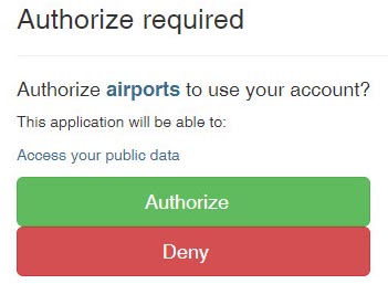
and you need to click the green button. This gives Airports permission to ask EuroGA for the authentication. You should not see that page again, unless you log out of EuroGA, or change the browser or computer.
2) Contribute as a Guest. The result is the same as above but you cannot return to the report afterwards to edit it, so you have to get it right first time, with all photos uploaded, before pressing Submit. Your report will be invisible until approved by Admins.
Note that even if you are a registered EuroGA user, you will not be able to edit a record which you created as a Guest.
Terms and Conditions
Standard EuroGA Terms and Conditions apply.
Contact
24th May 2021